1 800 363.8727

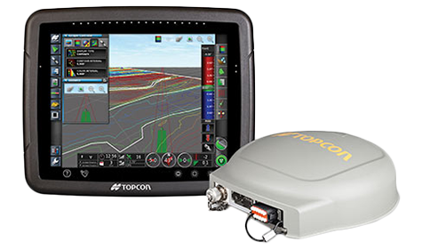
Topcon's System 310 incorporating Topcon’s AGS land leveling, surveying, and field design capability. AGS is a time-tested and proven control system that now operates on the X30 multi-function touch-screen controller.
Gather field surveys in minutes right from the cab, then set desired field slopes, or let the AGS software calculate best-fit slopes and reduce yardage. System 310 features Topcon’s proven dual-constellation GPS + GLONASS satellite reception for higher accuracy and 24/7 operation.
Gather field surveys in minutes right from the cab, then set desired field slopes, or let the AGS software calculate best-fit slopes and reduce yardage. System 310 features Topcon’s proven dual-constellation GPS + GLONASS satellite reception for higher accuracy and 24/7 operation.
System 310 incorporates the new MC-R3 receiver and MC-A1 antenna.
Features: